

The best hiking destinations in Brazil: Trekking vacations for active travellers
- Jul 29, 2025
- 12 min read
Updated: Oct 19, 2025
Brazil has an extensive network of hiking destinations that range from tropical rainforest to high-altitude savannah. While many international travellers associate Brazil primarily with its cities and beaches, the country also offers a wide variety of treks suitable for beginners and experienced hikers. Popular hiking spots include Rio de Janeiro, Ilha Grande, Chapada Diamantina, Chapada dos Veadeiros, Serra do Cipó and Lençóis Maranhenses, among others. These locations offer access to national parks, state reserves and ecological corridors, and many combine hiking trails with waterfalls, canyons or remote coastal areas.
Hiking seasons vary by region depending on rainfall and temperature. The country's ecological diversity is reflected in its trail environments, from Atlantic Forest remnants to cerrado plateaus and dune systems. Understanding terrain, climate and trail infrastructure is key to planning a hiking-focused trip in Brazil.
Before you embark on any hiking trips in Brazil, make sure you download offline maps on Maps.Me. This is the most reliable resource for hiking, especially on the majority of Brazil's trails where you will not have phone signal.
Don't have time to read the whole article? > Find cheap accommodation for your stay in Rio de Janeiro > Find cheap bus tickets to Rio de Janeiro
Here are my top 12 destinations to go hiking in Brazil
Here are my top 12 hiking destinations in Brazil, and don't forget to check my packing check-list at the end of this post to make sure you have everything you need for your hiking trip.
1. Hiking in Rio de Janeiro

Rio de Janeiro is Brazil’s most visited city and is best known for its beaches and nightlife, but it is also one of the best cities in the country for accessible hiking. The city is surrounded by protected areas such as the Tijuca National Park and Pedra Branca State Park, preserving biodiversity and native vegetation within the city. Rio is really a unique hiking destination as many of its trails are accessible by public transport or short drives from the city.
The climate is tropical with high humidity, and the terrain includes cliffs, rainforests, and coastal areas. The coastline meets steep granite peaks that rise sharply from sea level, offering dramatic elevation changes and so many viewpoints, each with its own unique views of Rio.
Popular hikes include Pedra da Gávea, a 2.5 kilometre trail with technical sections and ropes, which provides panoramic views over the Atlantic Ocean and the city. Another well-known trail is Morro Dois Irmãos (the Two Brothers Hike), offering a relatively short but steep ascent with views over Ipanema and Rocinha. The Parque Nacional da Tijuca also features Pico da Tijuca, the highest peak in the park at 1,021 metres, and the Bico do Papagaio trail.
Hiking trails in Rio de Janeiro:
Pedra Bonita: 3.1km / 1.9 miles round trip. (trail map)
Pedra da Gávea: 7.2 km / 4.5 miles round trip. Takes 6-8 hours (trail map)
Morro Dois Irmãos: 3km / 1.8 miles round trip. Steep ascent with incredible views over Ipanema. Take a moto-taxi from Praco do Vidigal (the entrance to the Vidigal Favela) to the start of the trail.
Pedra Telegrafo: 3.6km / 2.2 miles round trip (trail map)
Pico da Tijuca: 15.2km / 5.9 miles. At 1,021m, this is the highest peak in Tijuca National Park (trail map)
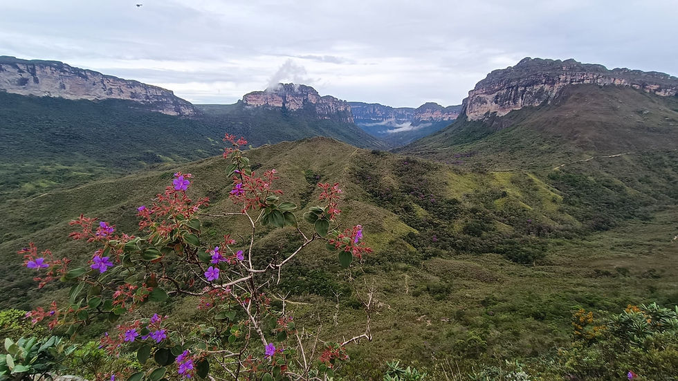
2. Hiking in Chapada Diamantina

Chapada Diamantina is a national park and highland region in Bahia known for waterfalls, table mountains and remote canyons. It is part of the Espinhaço Mountain Range with plateaus, valleys and semi-arid highlands. The terrain includes sandstone cliffs, underground rivers, and caves. The area spans over 1,500 square kilometres and includes cerrado vegetation and Atlantic Forest patches. The Vale do Pati is the most famous hike, but many visitors opt for day hikes to waterfalls and summits.
The Vale do Pati trek is the most famous, a multi-day route covering 60+ kilometres with basic lodgings with local families in the valley. This trek crosses canyons, high plateaus and forested valleys. Other day hikes include Fumaça Waterfall, one of Brazil’s highest, and Morro do Pai Inácio for a panoramic summit. The Lençóis area serves as a base for many trailheads. Local guides are common and often required for overnight routes.
Hiking trails in Chapada Diamantina:
Vale do Pati: The best multi-day hike in Chapada Diamantina, with options to trek for 3-5 days
Fumaça Waterfall (Upper): 11.7km / 7.3 miles round trip from Vale do Capao (trail map)
Cachoeira Sossego: 12 km round trip from Lencois (trail map)
Cachoeira do Buracão: 5km / 3.1 mile round trip. Waterfall inside a canyon, drive to the start of the trail from Mucugê (trail map)
See my full list of the best day hikes in Chapada Diamantina
3. Hiking in Chapada dos Veadeiros

Chapada dos Veadeiros National Park is known for its clear rivers and quartz formations and is one of the most visited parks in the central Brazilian plateau. It is located in the Brazilian Cerrado biome, with high-altitude savannah, quartzite rock formations and canyons. The terrain features plateaus over 1,200 metres in elevation and fast-flowing rivers. Most hikes lead to waterfalls, swimming holes and scenic viewpoints. The park is located around 3 hours drive from Brazil's capital city of Brasilia.
There are several trails inside the Chapada dos Veadeiros National Park area. Official trail maps and information for these hikes, which depart from the national park visitor's centre, can be found on the official website of the park. Aside from those inside the national park itself, there are many other waterfalls that can be visited as day trips from the towns of Alto Paraíso, São Jorge, and Cavalcante. The terrain is often rocky and exposed, requiring sun protection and adequate water.
Hiking trails in Chapada dos Veadeiros:
Travessia das 7 Quedas: two day hike passing through an established campsite (trail map)
Complexo dos Macaquinhos: 4.5 km / mile round trip, passing by several waterfalls (trail map)
Saltos do Rio Preto: 11 km / 6.8 mile loop (trail map)
Cascata dos Couros: 3.1 km / 2 mile round trip (trail map)
Cachoeira Santa Barbara: 2km /1.2 mile easy round trip (trail map)
Vale da Lua: A short 1km loop through scenic rock formation
4. Hiking in Ilha Grande

Ilha Grande is a car-free tropical paradise off the Costa Verde (Green Coast) in the state of Rio de Janeiro, known for its quiet beaches, historical sites and preserved Atlantic Forest. It is possible to hike the entire perimeter of the island using interconnected trails. The island's geography includes mountains, beaches, and rivers, with the highest point being Pico da Pedra D’Água at over 1,000 metres. The climate is tropical and humid, supporting dense forest and diverse wildlife. Hiking here connects beaches, ridgelines and inland forest routes.
Key hikes include the 12 kilometre trail from Vila do Abraão to Lopes Mendes Beach and the Pico do Papagaio trail which climbs to over 900 metres. The island features a trail network exceeding 100 kilometres, including multi-day routes such as the crossing from Abraão to Aventureiro. Trails connect remote beaches, waterfalls, and former prison ruins, offering both nature and historical interest. Infrastructure is basic, with signage and trail maps available locally.
Hiking trails in Ilha Grande:
Circumnavigate Ilha Grande: 69km / 43 miles, multi-day hike to complete the full island circuit
Vila do Abraão to Lopes Mendes Beach: 13.5 km / 8.4 mile round trip, coastal forest trail (trail map)
Pico do Papagaio: 9.8km / 6 mile round trip, peak climb to over 900m (trail map)
Dois Rios: 14km / 8.7 miles (trail map)
5. Hiking in Ilhabela

Ilhabela is better known for its beaches and waterfalls, but is also an underrated hiking destination with extensive trails across steep, forested terrain. It is a coastal archipelago in the state of Sao Paulo with steep mountains, dense Atlantic Forest and many waterfalls. It is part of a state park and covers 348 square kilometres. The terrain includes volcanic rock, steep slopes and a humid coastal climate that supports diverse flora and fauna.
The trail to Bonete Beach is one of the most well-known passing rivers and small communities. Castelhanos Beach can also be reached by a longer hike or 4x4 vehicle. Other trails include Cachoeira do Gato, a short but steep route to a tall waterfall, and the Baepi Peak trail, which climbs over 1,000 metres with an amazing view from the top. Some routes are used by the traditional caiçara communities for access.
Hiking trails in Ilhabela:
Bonete Beach: 10.3 km / 6.4 miles one way through forest and rivers, return by boat (trail map)
Pico do Baepi: 6.6km / miles, steep ascent to summit over 1,000m (trail map)
Castelhanos Beach: 16.4km / 10.2 miles one way, possible to return by jeep (trail map)
Cachoeira do Paqueta: 1.5km round trip - short jungle trail to a large waterfall (trail map)
6. Hiking in Serra dos Órgãos National Park
Serra dos Órgãos is located in the state of Rio de Janeiro and features some of the most technical and scenic mountain trails in Brazil. The park lies in the Serra do Mar mountain chain and includes steep granite peaks, montane forest and alpine grasslands. Elevation ranges from 100 metres to over 2,200 metres. Hiking here includes strenuous multi-day routes and shorter day hikes to peaks and viewpoints.
The Travessia Petrópolis-Teresópolis is a 30 kilometre multi-day hike considered one of the best in Brazil. It crosses alpine terrain and offers views of rock formations like Dedo de Deus. Other day hikes include the Cartão Postal trail and several other routes. The park has established campsites, water sources and ranger stations.
Hiking trails in Serra dos Órgãos:
Travessia Serra dos Orgãos: 3 day hike from Petrópolis x Teresópolis (trail map)
Bomfim to Morro Açu: 15.1 km / 9.4 miles round trip (trail map)
Mirante do Inferno & Pedra do São João: 12.4 km / 7.7 mile round trip. Pedra São João has a summit of 2,020 meters (trail map)
Mirante Cartāo Postal: 2.6 km / 1.6 mile round trip (trail map)
7. Hiking in Serra do Cipó National Park
Serra do Cipó is one of the most visited hiking regions in Minas Gerais and offers easy access to trails from Belo Horizonte. It is located in the Espinhaço Mountain Range and features cerrado vegetation, rocky fields and rivers. Elevations vary from 700 to over 1,600 metres, with grasslands and rock outcrops. Trails include waterfalls, plateaus and viewpoints over canyons.
The park has one of the highest densities of trails in Minas Gerais. The Bandeirinhas Canyon hike is 20 kilometres round trip through cerrado and along riverbanks. Other trails include Cachoeira da Farofa (8 kilometres) and Vale da Bocaina. The area also includes rock climbing routes and birdwatching trails.
Hiking trails in Serra do Cipo:
Vale do Travessão: 17.3 km / 10.7 mile round trip (trail map)
Bandeirinhas Canyon & Cachoeira Farofa de Cima: 25.4 km / 15.8 mile round trip (trail map)
Cachoeira do Tombador: 16.6km / 10.3 mile round trip (trail map)
Cachoeira do Gavião & Cachoeira Andorinhas: 13.2 km / 8.2 mile round trip (trail map)
8. Hiking in the Amazon Rainforest

The Amazon rainforest is the largest rainforest in the world and known for biodiversity and river systems. It is a tropical lowland forest with dense vegetation, rivers and high biodiversity. The terrain is flat and interlaced with rivers and floodplains. Hiking is limited to short guided forest walks near lodges or reserves, often combined with canoe travel.
Hiking in the Amazon Rainforest:
Access is limited and often guided. Trails in places like Presidente Figueiredo or Mamirauá Reserve are short and combine forest trekking with canoe travel. Seasonal variation affects trail conditions, and visitors must prepare for heat, insects and rain. Multi-day jungle expeditions are usually available through jungle lodges and tour companies.
9. Hiking in Lençóis Maranhenses National Park

Lençóis Maranhenses National Park is known for its shifting white sand dunes and rain-fed lagoons, which form an unusual landscape for hiking. It is a coastal dune field interspersed with freshwater lagoons, extending inland from the Atlantic coast. The dunes stretch for over 1,500 square kilometres.
The famous multi-day hike from Atins to Santo Amaro passes through dune fields and lagoons. Shorter guided treks from Barreirinhas are also common. The best hiking season is from June to September when lagoons are full. Most hikes are across open sand and require experienced guides due to the lack of signage and sun exposure.
Hiking trails in Lencois Maranhenses:
Atins to Santo Amaro Trek: Around 75km / 46.6 miles, 3-4 day multi-day crossing of dunes and lagoons
Lagoa Bonita: Around 1 hour walk, steep dune climb for sunset views
Lagoa Azul Trail: Hiking time depends on tour taken
Queimada dos Britos Trail: 32.7km / 20.3 miles round trip, community visit through dune fields (trail map)
10. Hiking in Itacaré

Itacare is a small coastal town in Bahia known for surfing, where forest trails connect directly to remote beaches. It is located along the Cocoa Coast, combining rainforest, rivers and beaches in a tropical lowland zone. The region is part of the Atlantic Forest biome and includes estuaries, mangroves and rocky headlands. Most trails here are short and link beaches with forest segments.
Hiking: Hikes in Itacaré often combine multiple beaches connected by forest trails. The route from Ribeira Beach to Prainha is popular and accessible. Other routes lead to Havaizinho, Engenhoca and Jeribucaçu beaches. Inland, visitors can hike to waterfalls like Usina and Noré. Trails are generally short and well-signed, with access possible from local roads or guided tours.
Hiking trails in Itacare:
Resende to Prainha Beach: 7.6km / 4.7 mile round trip. Scenic coastal trail passing Resende, Tiririca, Costa, Ribeira and ending at Prainha Beach (trail map)
Four Beaches Trail: Half day trip passing through Itacarezinho, Camboinha, Havaizinho, and Engenhoca Beach (read my full guide)
Usina Waterfall & Jeribucaçu Beach: 3.8 km / 2.3 miles one way, jungle trail passing through mangroves (read my full guide)
11. Hiking in the Pantanal
The Pantanal is known as one of the best places for wildlife viewing in South America. It is a vast floodplain with flat terrain, seasonal wetlands and savannah patches. It is one of the largest tropical wetlands in the world, covering around 150,000 square kilometres. Hiking is usually part of wildlife excursions on private reserves and includes interpretive nature walks.
Hiking is typically done on private reserves such as those near Miranda and Corumbá. Trails often combine walking with wildlife observation, especially during the dry season. Habitats include gallery forest, campos (grasslands), and floating vegetation. Short trails allow viewing of species like jaguars, capybaras and hyacinth macaws.
12. Hiking in Jalapão State Park
Jalapão is known for its red dunes, clear springs and remote access. It is located in the cerrado biome with dunes, rock plateaus and veredas (palm wetlands). The region includes sandstone mesas and rivers like the Rio Novo. Most hikes are short and reach unique geographic formations or springs.
Hikes are generally short and involve access to features like the Serra do Espírito Santo, Fervedouros (natural springs), and Cachoeira da Formiga. The hike up Serra do Espírito Santo offers a viewpoint over dunes and rivers. Trails are sandy and best accessed with 4x4 vehicles and guides.
Best hikes in Jalapão State Park:
Serra do Espírito Santo: 6.61 km / mile round trip, sunrise climb trail (trail map)
Fervedouro do Ceiça: easy 1km round trip, access to a spring
Cachoeira da Formiga: short walk to waterfall
Dunas do Jalapão: dune crossing with sunset views
What to pack for your hike
Check off these items to make sure you have everything you need for your hike:
Lightweight, breathable clothing suitable for tropical and subtropical climates, including long-sleeved shirts for sun and insect protection
Hat and sunglasses for sun protection
High SPF waterproof sunscreen, and insect repellent
A light-weight waterproof jacket - I like the Baleaf brand that is specifically designed for hiking and comes in both a men's and women's design.
Comfortable hiking boots and spare socks
A good refillable water bottle - I prefer an insulated one to keep my water cold all day. Depending on your destination, water purification tablets or a filter can be useful.
Personal first aid kit (bandages, antiseptic, pain relief, blister care)
Swimwear and a lightweight towel - as many of Brazil's best hikes come with waterfalls and pools to take a dip. Sandals or flip-flips are also useful for swim stops.
Depending on your destination, it may also be useful to bring a waterproof bag.
Obviously, plenty of snacks. For day trips you can also pack a picnic lunch.
For multiday hikes, consider also bringing:
Personal hygiene items (biodegradable soap, toothbrush, etc.)
Hammock with a built-in mosquito net - I like the Miztli brand hammock for hiking as it's lightweight and comes with a variety of accessories for easily hanging up the hammock
Lightweight sleeping bag. Though Brazil is generally a hot country, it can get cold at night, especially in mountainous regions.
Portable battery - especially important if relying on your phone for maps
Headlamp or flashlight with extra batteries
More resources for planning your trip to Brazil
Find cheap bus, ferry, and private transfer tickets on Bookaway, where you can make reservations ahead of time from abroad. Or, rent a car and give yourself the freedom to explore at your own pace.
Find your perfect accommodation on Booking.com, with thousands of options ranging from luxury hotels to budget-friendly backpacker hostels
You're not ready to travel until you have travel insurance. I recommend Safety Wing to my friends, family, and anyone travelling internationally. Get a free quote
Forgetting something? Read my packing check-list for Brazil, and my list of 10 things you should do before you travel to Brazil


Comments